
MapRun is an Android/iOS orienteering app that provides GPS based
punching and timing for courses. You can download it from either
the Google Play or Apple App Store, as appropriate. You should
always install or update to the latest version, as the app is under
active development, with new features being added regularly. This
guide aims to provide a quick introduction to installing and using the
MapRun
app, along with links to additional sources of information.

You need to install the MapRun (v7) (or older MapRun6) app on your smartphone, tablet or similar device. You can download it from either the Google Play or Apple App Store, as appropriate. You should always install or update to the latest version, as the app is under active development, with new features being added regularly. Note that you do want MapRun version 7 (or 6), not the older, now superceeded, "MapRunF" or "MyOMaps" apps.
Note that the MapRun app needs access to the GPS (location services), and to operate "in the background", so the track is recorded and controls are punched. These settings have changed in different O/S versions. You need to allow the app access to location whilst it is running. Also, many device manufacturers are making it more difficult to allow apps to run in the background, as this drains the battery. Hence you need to configure your phone Settings to allow MapRun to do so. How this is done depends on your phone, but usually involves the Power Saving or Screen Timeout settings. Some guidance on doing this is provided on the MapRunners Phone Settings page.
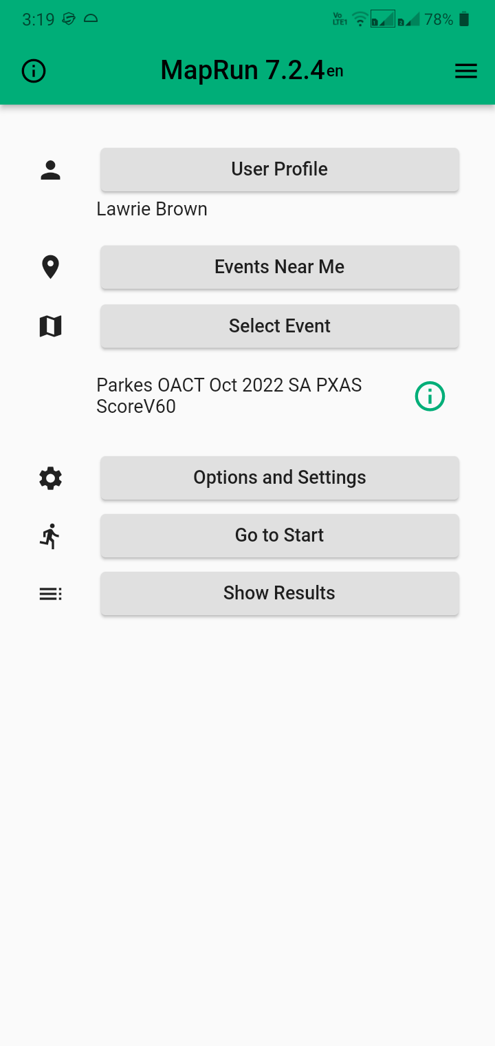
When you start the app, you will see the home screen, similar to this image. When you run the app for the first time, you should select the "User Profile" tab, and fill in your "User Details". Ideally all fields need some value.
The various tabs provide access to the following features (with more details on key operations given below):
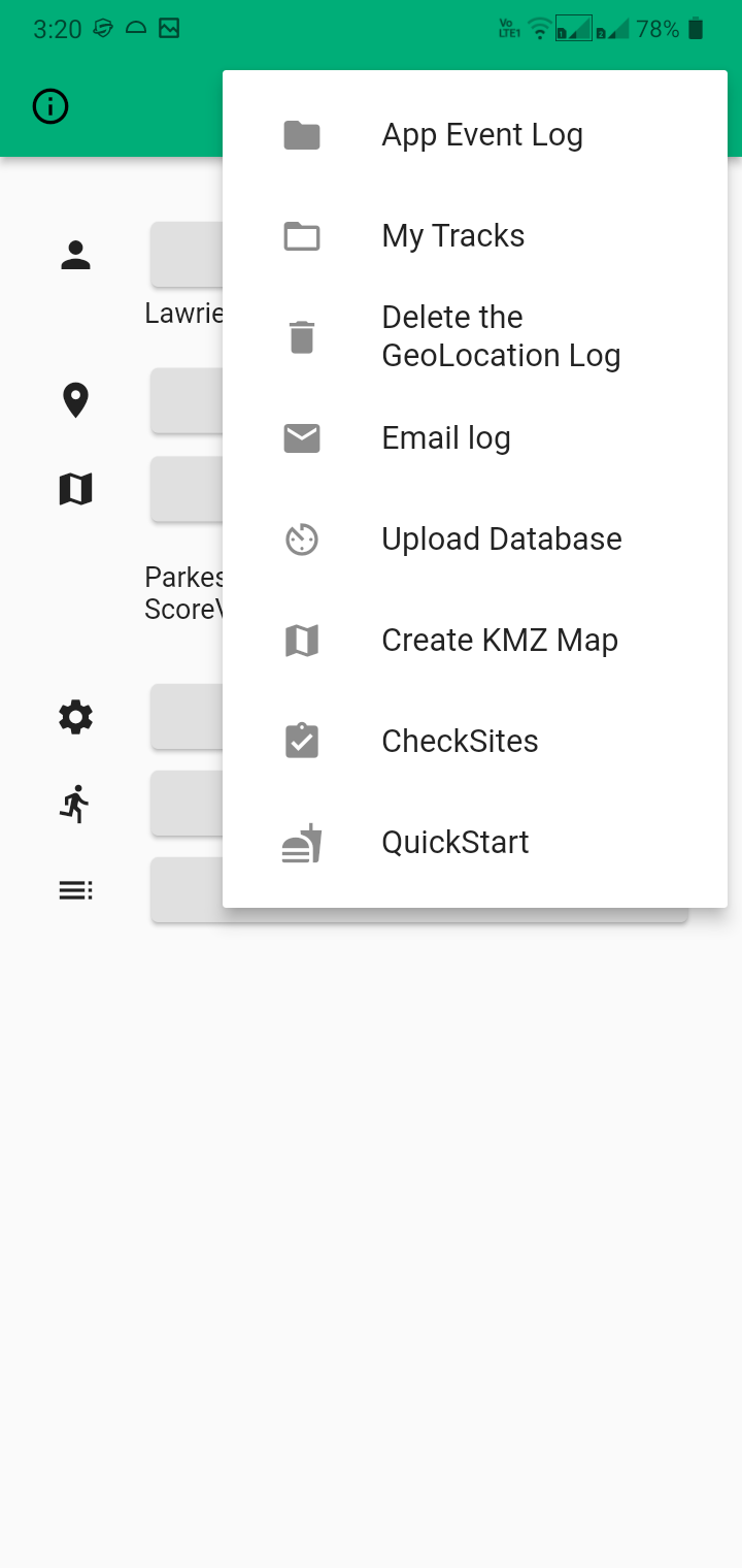
Some tabs have a Menu icon of 3 lines at the top right of
the title bar (in older versions of the MapRun app it may be 3 lines
inside a green circle at the bottom right of the screen). It is
used to access a popup menu of more advanced features (see screenshot
bottom for the features accessed from the Home screen).

You access permanent, public courses by choosing "Select Event". If you don't have data access on your phone normally, you should do this whilst near a suitable wifi hotspot, and the event details will be downloaded to your phone. Otherwise you can just do this at the event start location.
Navigate the folders to find the desired event (eg. "ACT", then "StreetO", then "Parkes OACT Oct 2022 SA") and select it. If you wish, you can select "Go to Start" to review the course. If you are not at the start location, select the Home icon (top left) and confirm abort to exit this view.
Alternatively, if the course map includes a maprun QR code, just scan the code with a QR reading app, and (once you agree the first time) the course will then load into the MapRun app ready to use.
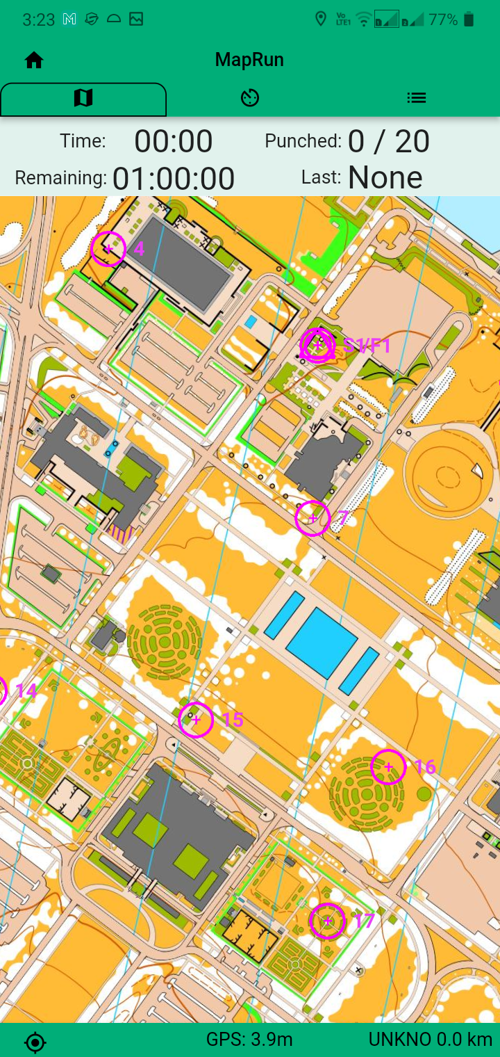
If on location and starting the course, first check the status bar at the bottom of the screen. This will start red (indicating no GPS lock), then change to yellow and finally green. If it stays red, then the app is not receiving GPS information. You need to check your phone settings to ensure the app has Location access (see the guidance and link above on phone settings). Assuming you have a green status, it provides an indication of your GPS accuracy, and a red dot will appear showing your current location, and confirming that your GPS is active. When you get close enough to the start location (S1), the app will beep, your location dot will vanish, and the timer starts for the course. You can now navigate the course, line or scatter as indicated, to each desired control in turn. As you approach each control, the app will beep, and the control will turn green indicating that it has been "punched". Note that your phone GPS will have a degree of error, so there may be times when you need to wait or hunt around a little, to punch a control. Continue until you have punched all the controls you want, and then navigate to the finish (F1) location (often co-located with start) where you register as finishing the course (successfully or not) once you punch it. Note that you must have punched at least one control before you can punch finish. The app will punch any control that you approach, and can punch a control multiple times, as long as you punch another control between. Any extra punches will be ignored when the app checks your course for validity after you finish. You just need to punch all needed controls in order (if a line course) or a suitable selection (scatter course) to have a successful result.
Important: do not approach the finish location until you are actually ready to finish the course. If you do and it registers, you will find your course run has been prematurely terminated! So take note of any course route choice that brings you back into the finish location vicinity, and keep far enough away not to register.
When you finish a course, the app will attempt to upload your result to the server. This will fail if you don't have data access at the time. You can always manually upload your result later if desired, as mentioned in the "Results" section below.
If you have downloaded a number of courses, they will all be permanently stored locally on your phone, unless you delete them. You can select any local (offline) course by choosing "Select Event". Then the "Access Local Events (Offline)" button at the bottom. Then select the desired event.
You may also want to access a temporary, private course, that someone has given you a map code for. To access these courses select the menu button on the Home screen, and select "Check Sites". Enter the map code and select OK. The course will be downloaded to the phone and selected, as long this is done before its expiry date on the server. You can now "Go to Start" to review or start the course, as with public courses.
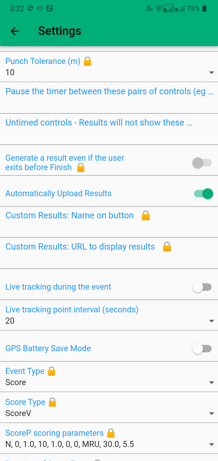
Before tackling a private course, you may wish to alter some of the "Options and Settings" being used for the course by selecting that button. You may want to tighten the "punchTolerance" from the broad default of 15m to a setting like 10m. This defines how close you need to be to the control location for it to register. Noting that your phone GPS will have a degree of error, so some amount of tolerance is needed. You can also change the eventType and scoreType from the default set by the tags in the course name. You can enable "Start Anywhere (SAW)" which lets you use any control as your (co-located) start & finish control (and the default finish becomes another regular control), useful if you want to check different parts of the course. You should check that "Display present location" is off unless you are deliberately checking the control placement locations.
You should use a Check Sites course to confirm the accuracy of your
KML file before publishing it as a public course (or indeed sharing
it privately with others). When doing this I recommend reducing the
"punchTolerance" to a value smaller than you would use on the
published course. So if leaving as default 15m, then check at 10m.
If using 10m (a typical value for a street orienteering course),
then check at 8m. Note this is about the lowest reasonable value
to use, given the typical phone GPS accuracy of circa 4-5m.
Results for any courses attempted are stored in the app locally on your device. You can review these results by selecting "Show Results". Select any result for more details.
Results for public events may also be uploaded to the server. You can select the "All Results" to view these.
When you are looking at a specific result, the menu icon (3 lines) accesses a drop-down menu which includes options to: show course timing details, review results, manually upload your results (if not done automatically), email your track to yourself, or to upload your track to Strava. The "Review Results (HITMO)" option can be used if some controls failed to punch for your course. Once you've finished and are reviewing your results, if some controls are missing you can select the menu button (3 lines) and then "Review Results (HITMO)". This lets you check how close you came to missing controls, and upload a revised result. You can vary the tolerance from the default 30m, though this is usually sufficient. You then need to scroll through the list of controls approached, and check the red box for any that didn't register but which you did pass. Then select the "Submit a Revised Result" button at bottom left to action this.
If you have reviewed a course, a "Did Not Start" result may be created.
You can delete any result (or local course) by "swiping left"
(or right :-) on the result and confirming delete.
More information about using this app is available at:
And if you want to explore creating your own MapRun courses, see
Lawrie's Guide to Creating
MapRun Courses
The following images show a few of the "Options and Settings" that may be viewed and changed (if not locked), and the Home screen menu items.

