Georeferencing with OpenOrienteering Mapper
MapRun courses need a geo-referenced map file, with lat/long
coordinates for the area covered by the map, and saved in Google's
KMZ format. Jon Glanville has documented the process of doing this
using OpenOrienteering Mapper (OOM) v0.9.5 or later. nb. versions
before 0.9.2 have a bug which causes errors in the result.
And you also need Google Earth Pro (GE) to identify geographic coordinates.
You can start with any of a non geo-referenced OCAD or OMAP file,
or a JPEG image, which you may have exported from a PDF map image,
such as one used by Purple Pen.
Creating a Geo-referenced OMAP File and KMZ
I briefly summarise this process here (adpated and extended from Jon's guide).
- You need to open or load this starting file in OpenOrienteering Mapper
using one of the following as appropriate:
- OCAD or OMAP map file
- • in OpenOrienteering Mapper "Open an existing map ..."
- JPEG or PNG file
- • in OpenOrienteering Mapper "Create a new map ..."
- • Use Template -> Open Template to load the map image file, specifying the dpi and map scale
- PDF
- • export it as a JPEG at 200dpi
(eg, using Preview on a Mac, or other program with similar functionality)
- • then import as a template as for JPEG above
- Purple Pen map
- • in Purple Pen, use File -> Create Image Files to save the All
Controls course, creating a JPEG at 200dpi (preferably one without controls)
- • then import as a template as for JPEG above
- Save or save as this map as an OMAP file. Note if was an OCAD
file this is important as the OCAD file does not keep as much
information as the OMAP file does.
- Identify two points to use for the geo-referencing locations.
Choose points that are far apart, and which you can identify
accurately on the map and on a Google Earth image
(I recommend adding placemarks at these locations on the GE image
for future reference)
- In OOM move the pointer to each of the two selected points, and
get the map coordinates of each (visible in the bottom right of the window). eg
A = (-63.44, 31.41)
B = (106.00, 25.43)
- Use Google Earth to get the geographic coordinates of these two
reference points. I find this easiest if I add a placemark at each location,
and then "Get Info" for each to see (and perhaps nudge to cleaner values)
the coordinates for each point. eg.
A = (-35.331238, 149.129181)
B = (-35.334722, 149.147314)
- Using Jon's Georeferencing
Calculator spreadsheet, enter the two sets of coordinates for the two
selected points, as well as the map scale, in the 9 yellow boxes.
Then note the calculated Rotation and Scale Factor in the blue boxes
- In OOM, select Map -> Georeferencing. In the dialog:
- select coordinate reference system "by EPSG code" and enter EPSG code 3857
(since this is what Google use, which we use to get our reference coordinates)
- enter map coordinates of the first reference point
- enter geographic coordinates of the first reference point
- enter the negative of the calculated Rotation value as the "Map North"
Declination
- enter scale factor from spreadsheet into the Auxiliary Scale Factor box
- click OK to save changes, and answer No to questions about
stretching/shrinking or rotating the map.
- You now have a geo-referenced OMAP file, which you should Save
- You can now also create a KMZ of this by selecting File -> Export as ...
KMZ, specifying 150dpi and keeping the tiling default. You can then open
this KMZ in GE to verify correct referencing of the map
Creating a Geo-referenced OCAD File
Since many orienteering maps have been created using the (very
expensive) OCAD program, and may not be geo-referenced, it is highly
desirable to be able save a geo-referenced OMAP file created from
this, back as an OCAD file. However this has been tricky, as the OCAD
file does not keep as much information as the OMAP file does.
- Open the geo-referenced OMAP file in OOM
- Select Map -> Georeferencing. In the dialog:
- select coordinate reference system "UTM"
(as that is what our local maps use, will be "55 S")
- click OK to save changes
- Save As a suitable OCAD format file (11 or 12 usually).
nb. You will get a warning dialog that information may be lost, that you
have to accept (because indeed it is, sigh).
- Close and re-open this OCAD file
- Select Map -> Georeferencing, and note in the dialog that the
Georeferencing reference point has been shifted to the (0,0) map location
with the geographic coordinates suitably updated, but also that the
auxiliary scale factor has changed
- You can now export it as a KMZ file, which you can check is correct in GE
(seems is very close but not quite the same as the KMZ from the OMAP file)
Creating a KMZ using the MapRunners O-Utils Convertor
Versions of OOM prior to v0.9.5 did not support KMZ export. We were
able to generate a KMZ using the MapRunners O-Utils Convertor, but
some additional steps were needed, as it requires the map to be
oriented to true north, and then exported as an image file with
associated world file.
- In OOM rather than using the calculated Rotation as the map declination,
select Map -> Rotate Map. In the dialog:
- enter Rotation angle from spreadsheet (remembering that it is negative)
- choose "Rotate about: georeferencing reference point"
- uncheck "Adjust georeferencing declination"
- then click OK
- Select File ->Export as Image. In the dialog:
- choose the page size and orientation (A4 landscape/portrait)
- click "Show templates"
- select "Centre print area" checkbox to centre image
(and adjust if necessary)
- choose 150 dpi resolution
- then click Export
This will save both the JPEG image file and the associated JGW world file
- In your web browser, open
O-Utils.
In the "Create a KMZ file..." section:
- browse to and select each of the JGP and JGW files created by OOM,
& and specify 150 dpi resolution.
It should look similar to image below.
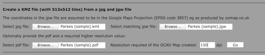
- then click Go
- In the next page, click the Save button to save the KMZ file.
Please send any comments, improvements, or other feedback to:
Lawrie.Brown@canb.auug.org.au
Guide last updated by:
Lawrie Brown - Tuesday, 09-May-2023 10:11:59 AEST